 |
|
Archway - Tower Bank |
Craster Chain Home Low Radar StationEstablished during the early years of WW2, the Chain Home radar system encircled the Coast, with the emphasis to the east and south, to protect Britain from attack by sea and air. The Chain Home radar stations featured tall towers that reached far out to sea and the Chain Home Low lower structures that did not reach so far out but which gave greater detail, allowing operators to identify aircraft and ships with greater accuracy. Craster radar station was one of the latter types. The radar station at Craster is situated a short distance north of the village on top of the whin stone heugh (escarpment) that extends from the village to Dunstanburgh Castle and which slopes gently down to the sea from a high point some 150m from the shore. This location, about 50m above sea level, gives the station a perfect 'view' out to sea.
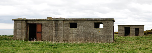
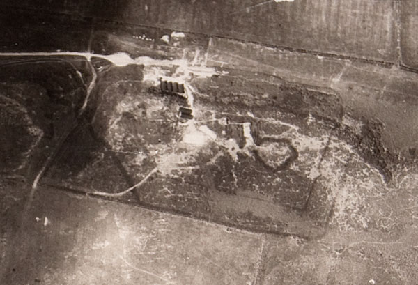
In this view, looking south, the operations block is in the foreground; the antenae was situated on top of this building, thus extending the station's range. The operations block housed the transmitter/receiver equipment, the operating/plotting console, telephone exchange etc.The smaller building, further away, is the generator block or power house. Both buildings are solidly built of reinforced concrete Accommodation and service buildings were located in the valley on the inland side of the heugh. These buildings were later used as accommodation for Italian prisoners of war. In 2003-2005 English Heritage undertook investigations into the radar station and produced the following report by Hunt and Ainsworth: 43/2006 - Craster, Northumberland: An Archaeological Investigation of a World War II Radar Station Complex. "The two principal buildings of the radar station (the TxRx block and the Standby Set House) are extant and were surveyed in detail. The remains of other buildings which would have formed part of the complex, including the bases of Nissen huts forming the accommodation and ablutions blocks, were also identified. A number of weapons pits sited in strategic locations around the radar station complex were recorded. These contributed to the wider coastal defences of the area. Examination of historic aerial photography revealed the position of some features which no longer survive, for example, barbed-wire entanglements defining the perimeter of the compound. Documentary research demonstrated that the radar station was probably built in late 1941 and continued in operation until July 1944. Subsequently, the radar station buildings and compound were used as a Prisoner of War camp until 1947. Oral testimony was gathered from local people who had been resident in Craster during World War II and this brought to light additional information about the use of the site." The full report is available for download here. An account of the station is given on the English Heritage Past Scape site. The following aerial image of the radar station, a detail of a much larger photograph, shows the site of the station and prisoner of war camp in June 1945.
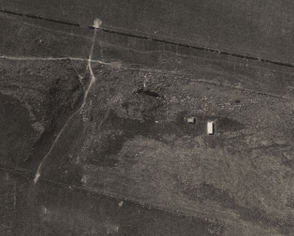
The larger photograph is made up of many separate images, cut and stuck together to make a coherent whole by Sir Ivan and Lady Sutherland, which extends from Craster to High Newton and from the sea to inland of Embleton. One of the images carries the following number, 106G/UK.24June'45.F/202//54.... Unfortunately the end of the number is covered by another part of the image and may continue for an unknown number of digits. The following photograph, taken on May 17th 1964 shows the site pretty well cleared, although the two concrete blocks of the station are evident.
References |
 |
Home Programme Membership Archive War Memorials History Walk Miscellanea Links Contact Us


